2 November 2021


Anyway, they have wifi. So I thought okay, good time to work on another blog.
After we left Wyoming, we got on I-80, drove to I-25 and headed south into Utah. Our plan was to skirt by the large cities like Salt Lake City and Provo, 
Some of the actual rocks and rock formations found in Utah are unique to this state. Really, not even the region - some of the rocks are found only in Utah! There are long and 
The oldest rocks in Utah are roughly 2,500 million years old - or actually, 2.5 BILLION years old. These and other rocks (a mere 16 million years old) were 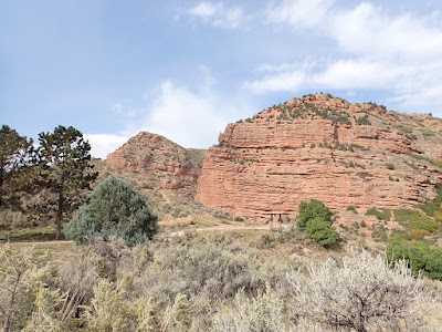
Newer rock built up on top of this foundation of ancient rock. Water deposited thick layers of various sediment above that. During some periods of time, Utah was under the ocean, or was near enough to the ocean that it would occasionally be flooded. More rock was deposited in some areas, while other parts of modern day Utah were eroded away.

During the time of dinosaurs, the region dried out, and much of the red sandstone built up. And yes, dinosaur fossils can be found across certain parts of Utah.
Plate tectonics caused compression of the sedimentary rock in some areas, so that some parts buckled up and turned into the jutting cliffs and peaks that we see today. The older rock was lifted up over the younger rock, exposing some of that really ancient basement or foundation rock.
HUGE uplifting created the Rocky Mountains, and on the Utah side there was downwarping - meaning low areas and basins were formed. There was continuing seismic (earthquake) activity, and then a series of volcanic activity occurred, creating igneous rock in parts of Utah. More earthquakes, more volcanic eruptions, and that all created the basic Utah landscape.
Some of the uplift during earthquakes re-directed rivers, or made steeper inclines, which eroded the rocks into various shapes and forms. The erosion continues during rainy season, and the wind also erodes some of the softer rocks (such as the sedimentary rocks like the red sandstone).
So, that's a brief explanation of Utah's landscape. All that geologic activity created a rather crazy and wild visual experience from an artistic point of view - and that is why people flock to the national parks here, to see these dramatic rock formations.
The first set of photos are from the rest area right at the northeast corner of Utah, entering the state on I-80. I don't know the name of the region, but the rocks were worth photographing. I've separated the rest of the photos by region, and the map showing our route is at the very end.

Kolob Canyon:

The next day, we drove to Cedar City, a larger town. We spent half of the day 
I only mention this because it meant we hung 
And the ONLY reason this is relevant is that we saw sizable groups of women walking through the parking lot, looking like a mash up of pioneer 

I did a little research and yes, these were most likely "sister wives" in some of the more religious (or conservative) Mormon groups.

Okay, so after we left, we took a drive through Kolob Canyons. This is a series of skinny finger canyons through and around looming rock formations. Dramatic, looking like rock fortresses complete with towers and turrets, rising up out of gentle hills. Imposing and ominous. This area runs along part of the Colorado Plateau, the name given to this high flat region encompassing several of the southwest states. And this is why we were constantly at a rather high elevation.
The other national parks we visited were drive throughs, meaning you can drive through the entire park and continue onward at the other end. (You can also stop and hike, and some have camping permits as well.) But Kolob Canyons is a one-way drive, with a turnaround at the end. The scenery is all on the way in - so if you drive there, be sure to stop at the various scenic overlooks. You really don't have a chance to see much on the drive back out.


Zion National Park:


Zion is full of red sandstone structures, often called Navajo sandstone. Actually, Navajo sandstone is the layered red and tan or beige sandstone built up through eons of sand dunes blowing across the 
The blowing wind and occasional rain have eroded the surface of the sandstone, causing the ripples and striations we

So the rock formations aren't as smooth as what we saw in Kolob Canyons. In Zion, the structures are more textured, some even looking like giant stacked building blocks.


It also was easy to image gangs of renegades hiding 

It is overwhelming, and powerful, to stand and look at these giant natural formations that make our human efforts look insignificant. It makes me feel small, like an ant. Or a creature with the lifespan of a butterfly. It's humbling, to realize that we humans are such a small part of this world.
Or as another traveller said, standing looking across the valleys and marvelling at the stone fortresses and rock formations, it makes you want to just stand there and bathe in all the beauty.
[Sorry about the jump in the narrative. There's a phantom space that I can't find, so I can't delete it. I've tried all kinds of things and it won't go away. Consider it a sign from the ancestors that yes, they live in Zion National Park.]


Bryce Canyon National Park:


We spent the night in Panguitch, another small town. (There is a lovely breakfast spot with authentic French croissants - absolutely worth a stop.)
Bryce Canyon National Park is sort of but not really a drive-through 

The rock formations in Bryce are totally different from the other national parks we visited in Utah. Apparently there was a lot more erosion in Bryce Canyon compared to the other canyons and parks. At Bryce, the erosion was caused by water, ice, and gravity. Not that there was less gravity here. But the rock at Bryce Canyon is 


The effects of erosion also show in the building block aspect of some of these pillars of rock (though the geologic term for the pillars is hoodoos - yes, silly as it sounds, these 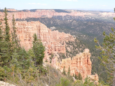


Additionally, some of Bryce is at a much higher elevation than the other parks. At one point, the scenic overlook was at 9800 feet above sea level. Nearly 10,000 feet! Yes, that is nearly two miles high, or over 3 km in elevation!!! (And yes, breathing is not easy at 
One of the sights everyone wants to see at Bryce is the Natural Bridge. This is a wall of rock with a hole that slowly eroded away an arch from the base of the wall upward, likely from rain funnelled downslope in the same place, century after century. It really is a 
Some of the walls of sculpted undulating reddish sandstone looked like photos I've seen of the pink palace in Jaipur, India. Really, with arched caves mimicking the windows and doors of the 
No wonder the original Native Americans here thought these canyons were inhabited by their gods. I could feel something spiritual, 
Given the other-worldly feel of the rocks, hills, winding canyons, it's easy to believe that this land is part of a different realm, the home of gods and spirits and ancestors. That there is a presence not of this world. And that maybe we humans don't really belong here. It feels like the land belongs to the spirits and ghosts who inhabit this place. The animals who live in the shadows of the mountains, who prowl the rocks at night, or who slink in the shadows, they belong here. The condors and eagles who soar overhead belong here.
But we humans who drive through, and marvel at the rocks, the mountains, the stone sculpted by time and nature? Who hike and camp and appreciate the beauty? No, we're just borrowing this land. We don't really belong here. We're interlopers. We're just a blip on the face of this landscape, this landmark of time immemorial, this testament to the forces of nature.
We pretend to understand, but we really don't. Instead, we stand in awe, awed by the beauty, awed by the strangeness, awed by the forces that created this land. Awed by the fact that we feel something we can't name. Being human, trying to understand, we give it a name - but whatever we call it, whatever we believe, we really cannot understand.
That's what these natural monuments do - they remind us that we humans really aren't in control. We're just living on the face of the Earth, borrowing the environment and the resources. We're not really living in harmony with the Earth, and we don't really feel part of it.
So we continue to flock to our national parks, hoping to connect with nature. Maybe we do. Maybe we don't.
I hope we continue to revere and honor nature, and our mother Earth. It really is an amazing place.


Grand Staircase from the LeFevre Overlook:

The information signs 
"The LeFevre Overlook view of the Grand Staircase is a quick snapshot of the most colorful part of the Colorado Plateau, laid out for hundreds of miles. The landscape includes a vast array of colors, textures, elevations, and one can see a span of millions of years in geologic time with 
"You are standing on the Kaibab Plateau, the first step on the staircase. Once the bottom of a shallow sea, the remains of prehistoric aquatic life can be found all over the plateau. An undercurrent of geologic forces lifted the 
"The Grand Staircase is a smaller part of the Colorado Plateau, which comprises a major part of the Four Corners region and is composed primarily 
"The Colorado River flows through the entire Colorado Plateau, exposing the lowest elevation at around 2600 feet at the bottom of the Grand Canyon, where high desert temps limit the vegetation to hardy desert survivors like creosote and mesquite. Meanwhile, within a hundred-mile radius, the highgest portions of the Colorado Plateau surpass 11,000 feet in elevation where are, thousand year old Bristlecone pine can be found."
That's the quick summary of what we saw throughout Utah, and what we see here from the overlook. The Grand Staircase is an imaginative way of describing the layers building up to the highest part of the Colorado Plateau, and the steps are the various levels created by the seismic forces lifting up different layers of rock.
Who knew that geologists could be quite so poetic?


Map of our route:
