Sunday, October 31, 2021

Pandemic Diaries - Year 2, Road Trip to Arizona Part III

 31 October 2021


Happy Halloween!


Continuing with our trip, we drove from Missoula to West Yellowstone, which is just outside the west entrance to Yellowstone National Park.  We both had enjoyed our drive through Yellowstone on our trek across the country last summer (albeit in our loyal car Tiki), so we thought since this trip brought us within a few hundred miles of the entrance, we might as well visit the park again.


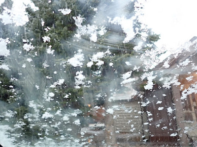
It's a road trip, not a race to the finish line.  The journey is part of the trip, it's just as important as the final destination.


Well, it turns out that West Yellowstone is at an elevation of 6,667 feet (or 2.03 kilometres).  As in, a high elevation.  We approached West Yellowstone in a rain storm.  And drove around the town, looking for an affordable hotel, in the same rain storm.  Except I noticed that this rain was slightly more solid than just rain.  I'm from Washington state, we know rain.  And this rain had snow or ice mixed in.


By the time we found the Pioneer Motel, a collection of cozy cabins, it was full out snowing.  Our windshield had globs of snow.  The bushes outside the cabins had snow, more than just a dusting.  And the snow continued to come down!  And it was SEPTEMBER!!!!  WAAAAY to early for snow, even at a higher elevation.


Yes, our cabin was heated.  We turned up the heat, added the extra blankets, went out for a quick dinner, and then had a warm and cozy night.


The next morning was a bit icy, so we held off driving until some of the ice and snow melted.  Then we joined the throngs waiting to enter Yellowstone.


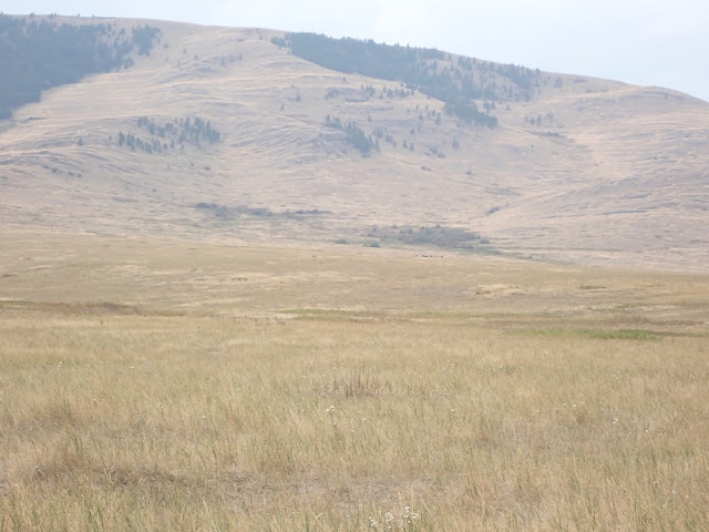
It really was beautiful in early autumn.  The aspen and birch trees (or maybe alder?  the white bark trees) were turning golden and orange, a beautiful contrast against the deep green evergreens on the hills.  The meadows were gold and amber, the sky cleared and was a soft blue, and it really looked like the perfect day for a drive through the park.


Turns out that the direct route through Yellowstone and then south through to Jackson was closed for construction work.  That meant instead of driving into the park and driving directly south, we had to drive east, then south, then a bit west, all around the other three sides of a square to meet up with the highway that would take us south to Jackson.


Okay, not a problem, that meant more time in the park, more time to view the animals and meet more bison.  Maybe even a wolf or two, or a bear if they weren't hibernating already.


It turned out that as we drove into the higher elevations of the park, we encountered more snow.  It had snowed here as well the previous day and night.  It was cold enough that the snow stayed.


The bison didn't seem to mind, it was just a couple of inches of snow.  They could easily push the snow out of their way and still munch on the grasses.  There were several herds of bison down near the river, and later on in the day up a bit of a hill.  I even saw several bison hoof prints in the mud left behind as the snow melted!


Well, we drove.  And we drove.  Up and down hills.  Through valleys and dales.  The road wound around, snaking back and forth and up and down.  We really weren't sure where we were, but we were following the highway through the park, and any signs that said either "south" or "to Jackson."


It was beautiful, as always.  There's a reason this area is set aside as a national park as well as an animal sanctuary.


Eventually, we starting driving up and down mountains.  It began to snow.  Up higher and higher.  More snow.  Even higher.  And then we hit blizzard conditions, were we could only see a few feet in front of the car.  The snow was piling up on the road.  Here we were in our little Toyota, without snow tires, without chains, driving in slushy snow accumulating to a few inches.  Yikes!


The "no traction" light lit up on the dashboard (who knew such a warning light existed???), and I said something about that to Richard.  He said well here's a button (near the parking brake), and he pushed it.  Something happened, because something suddenly gripped and while we did slide a little at that first grip, it definitely became easier to drive in this snowy slush, or slushy snow.


After a while the road headed downward, and our blizzard eased up to just normal snow pelting down.  A bit more driving downhill, and we made it to elevations low enough to not have an active snow storm, just accumulated snow again.


Whew!!!


This is actually where we found another herd of bison, as well as a few elk nearby.  So, more bison photos.  They're so cute.   If you look closely, you can see a young bison touching noses with its mother (on the right end of the photo).  And two young bison having a little bit of a shoving match (far left side)!


We passed several of the steaming vents or fumaroles for which Yellowstone is known.  I mentioned this last summer, but basically, much of Yellowstone is a volcanic crater or caldera.  So there's a lot of geothermal activity underground - the magma heats water or mud, which bubbles up to the surface or sends  of sulphurous steam.  


Tons of people were walking by and through the steam, but ugh, it just smells so horrible!  The entire parking area near each of these steam vents just stank!  I held my breath long enough to get a few photos at one, but most of them were so smelly we didn't even want to get out of the car!!  Well, one parking area also had restrooms, and that's where I found the bison hoof prints.


We continued southward on highway whatever it was, and apparently left Yellowstone.  There's a little bit of non-park land, and then suddenly we were in Grand Teton National Park.  The Teton Range is the youngest group of mountains in the Rocky Mountain range, which is why they have such a steep, sharp, and craggy appearance - they haven't had as many eons and millennia to weather and erode.


But those majestic peaks were hidden in the clouds, and likely shrouded with the same snow that we had just encountered in Yellowstone.


So we have mysterious and vaguely sinister photos of the Tetons, hiding their secrets in the misty clouds.  


The fields and trees in the front made a nice golden foreground for the blue-grey mountains rising in the distance.  And yes, there is snow on the sides of the mountains, before they disappear into the grey gloom above.


That really was all we saw of the Grand Tetons - the base of the mountains.  Oh well, this may mean we have to visit again.  Hopefully on a sunny day.


We drove south to Jackson, and tried to find an affordable hotel.  We stopped at some hotels/motels and asked.  We used free wifi and looked.  We got phone numbers and called.  Everything was insanely expensive, and most places only had one or two rooms still available so we guessed they were raising prices even more.  While we don't mind spending a bit more for something special, over $350 for one night is pretty insane by our standards.


So we got directions for the road heading south.  I actually found a young woman in her car who used her smartphone to get directions for us.  She couldn't comprehend how we drove around without a phone or GPS.  I said we use an atlas, and she had no idea what an atlas was.  I said it was a book of maps, and we had several maps for each state, so it made it easy to figure out how to get from place to place.  But that we didn't know what intersection we were at right at that moment, so that's why I asked her for directions.  (It was more than just a generational gap, it really was almost a technological gap!!!  For both this young woman and for me!)


Anyway, south we drove, on a small county highway, with more winding around hills and the golden full moon rising in the distance.  At twilight, we saw a huge moose standing in someone's yard, eating some greenery.  HUGE!  And those antlers!!!  Wow!!!  (I was driving, plus it was a bit dark for a decent photo.  But it would have been an amazing picture, with this humongous moose just grazing in a garden!)


We probably drove for about two hours, not even passing a single town!  Then suddenly we arrived at a tiny place called Daniel Junction.  The actual town of Daniel was a few miles south.  But at the junction, there was a gas station with a convenience store that also sold sandwiches and burritos.  And, wonder of wonders, they had a motel in the back!  YAY!  We really were in the middle of nowhere, but the staff people were friendly, the room was clean and warm, and the food was pretty decent.  There also was wifi, so we checked in with family, and fell sound asleep.


The next morning we headed south again, and our next stop was the town of Evanston, WY.  It was a nice small town, and we decided to spend two nights there while we planned the next leg of our trip.  We used the hotel's laundry, drove around the town a bit, found the river, and basically just did some low key exploring.


We thought we both needed a short break after that crazy day of the blizzard and the long evening of driving through the wilderness.


It definitely has given us a taste of what it might have been like during the era of western expansion.  Not as rough as travelling on horseback or in a covered wagon, obviously.  But travelling through unexpected weather, and not being able to find a place to spend the night, really does make us more aware of the hardships people experienced as they left their homes and headed west to settle in new regions.  


It was an experience!


Tuesday, October 26, 2021

Pandemic Diaries - Year 2, Road Trip to Arizona Part II

26 October 2021


I explained in my last blog that we drove from Bellingham, Washington, to Tucson, Arizona, where we will winter over.  Or winter.  Or spend the winter.  Regional differences and slightly different meanings, but yes, we'll be here until next spring.


The drive across Washington was pretty basic - we drove south on Interstate 5 (I-5) to a bit north of Seattle, took I-405 around to the east side of Lake Washington, and headed east on I-90.  We spent two days in Yakima, then headed east again.  Central and Eastern Washington are basically considered high desert.  The Cascade Mountains create the very green and wet environment of Western Washington, but they also cause the region east of the mountains to be in a rain shadow, and therefore a desert region.  We stopped at a few rest areas, and I took some photos to show how really dry and almost arid this part of the state can get.


We continued on I-90 across the northern panhandle of Idaho, and didn't really stop until we were in Montana.  The area around Lake Coeur d'Alene, Idaho, looks lovely, but it's always rather crowded with vacationers so we always drive on through.  Northern Idaho is very hilly and green, more like western Washington, as we begin the climb up to the Rocky Mountains in Montana.  And western Montana is also full of huge evergreen trees, hills, lakes, rivers.


We stopped at a rest area that had really interesting info signs as well as lovely views of the river and hills beyond.  One sign focused on the bald eagle, which was once an endangered species but now, due to conservation efforts and habitat protection, the eagles have made a comeback in Montana; the nesting sites have increased from about 17 sites in 1980 to over 300 sites today.  One nesting area was visible from this scenic rest area, but I didn't see any eagles nearby.


The second sign gave all kinds of information about the geology of this area.  About 15,000 years ago, during the most recent ice age, a huge glacier moved down from British Columbia, Canada, and blocked the Clark Fork River in northern Idaho.  This ice dam created the largest glacial lake known to have ever existed, Glacial Lake Missoula.  The body of was was comparable to the size of Lake Ontario today!  This backed-up water eventually broke through the ice dam and the huge amount of water rushed toward the Pacific Ocean, triggering epic floods that scarred the landscape especially of eastern Washington.


Additionally, this ancient lake refilled and emptied seasonally for the next 2000 or so years, and evidence of the changing shorelines can still be seen as one drives across the region. 


It really was interesting, and explained part of why eastern Washington is so flat and barren!


We spent a day in Missoula so I could drive north and visit what was previously called the National Bison Range, established in 1908 and once part of the National Wildlife Refuge System.  In 2020, the US Congress returned the Bison Range to the Confederated Salish and Kootenai Nations, the people who originally inhabited this region and who have their own cultural traditions and interactions with the bison.


I'm not exactly sure how to pronounce the names of the Native American nations that make up this confederation, but one sign included SéliÅ¡ (the people we call Salish), Q´lispé, and Ksanka people as the stewards of the Bison Range.  (Q´lispé really shouldn't be an apostrophe before the L, it's more of an accent mark over the L.  But my keyboard is limited in what I can do with it.)


Anyway, the National Bison Range was originally established to provide a refuge for the bison in western Montana, and the current Bison Range carries on that mission and tradition.


The bison here at the Bison Range are descended from a free-ranging Reservation herd started by tribal members in the 1800s, when plains bison were near extinction.  A Pend d'Oreille man, Little Falcon Robe, travelled to the northern Great Plains and returned to his home on the Reservation here with a group of bison calves.  Their descendants live at the Bison Range today.  There are currently between 350-400 bison here at the Range, and an estimated 500,000 bison on public and private land in the US today.


There was the usual information about bison being large animals up to 2000 pounds (900 kg!), able to run as fast as 30 mph (almost 50 mph), and able to jump as high as 4 or 5 feet (1.3 to 1.6 meters).  That for our safety, we should remain in our cars, and only walk on designated trails.


I paid my entrance fee at the visitor's center, received a lovely day pass to hang on the rearview mirror (though I just put it on the dashboard, I find things hanging from the mirror are very distracting), and asked about the two drives.  The longer drive is the Mountain Drive, which begins as a one-way drive and skirts the foothills to the mountains on the northern border of the range.  This drive then meets up with the Grasslands Drive, which is a two-way drive.  But since the Mountain Drive is one-way, those driving on the Grasslands Drive need to turn around and return the same way they came.


Turned out the best chance of seeing bison is on the Grasslands Drive, so I headed off that way.  Of course, I'm not good at following directions, and the woman who gave me directions had me quite confused, so I got totally lost and ended up at the picnic grounds below the entire range.  I met a friendly family group who tried to help me, but they were equally confused by my map and my directions.  So I went back to the visitor's center, and the woman gave me very exact directions, and I headed off on the Grasslands route.


The scenery was beautiful - all fields and gentle slopes of golden wheat and amber grain.  Tiny flowers in the grasses alongside the road.  Dark green conifers on the taller hills beyond the grassy areas.  Dotted random trees and bushes, some craggy rocky outcroppings.  Stark but beautiful, with clouds scudding by overhead because it was a windy day.


Well, the bison were way up on the hills of the grasslands region.  Too far for good photos, but they're the little dark dots up on the flattish areas of the long hills.  They weren't close enough to the road for personal photos, but at least they were somewhat visible.  It was a little disappointing, but, well, free range animals are just that, free to range wherever they want.  As much as I like to see them close up, they have no obligation to do so.  They also have little desire to meet me in person, no matter how much I'd like to think that they know I'm their friend, and they would be my friend if they met me.  (Really, I do know how unrealistic that thought is.)


I did see quite a few pronghorn antelope, the females mostly nibbling grass or using the longer grass as camouflage.  There were also small groups of female elk and deer trotting around.  If you look closely at some of the photos, you can see a somewhat blurry deer or elk in there.


One male pronghorn did come by near enough for a few decent photos.  He really was majestic, listening for any danger, trying to protect his herd of females, as they walked through the tall grasses.


Clouds kept blowing through, and the wind started picking up.  When I finished the Grasslands Drive, I could see rain approaching from the west, so it seemed like a good time to drive back to Missoula.  


It was absolutely worth this little side trip, even though I didn't get to see any of my bison friends close up and personal.  Some enlarged photos, and there are larger versions of the maps showing our general route.