 NOTE: We're now in Valparaiso, Chile. But I have about 15 or so blogs from our cruise, so I'm going to post these a few per day, in chronological order. I'll try to remember to add this note so that people know to go back a few
  days.
days.
Days in Antarctica: 8, 9,
10, and 11 February 2020
11 February 2020
We’re currently out of Antarctica, and I’ve been thinking about our experience
there. This is one of those places that
is difficult to describe, because it is so
out of Antarctica, and I’ve been thinking about our experience
there. This is one of those places that
is difficult to describe, because it is so  vast, so outside the norm, so
overwhelming, that words seem almost useless.
Antarctica really is a world unto itself, with its own climate,
environment,
vast, so outside the norm, so
overwhelming, that words seem almost useless.
Antarctica really is a world unto itself, with its own climate,
environment,  eco-system. The beauty of
this continent is stark and other-worldly.
The standards of beauty that we apply to scenery
eco-system. The beauty of
this continent is stark and other-worldly.
The standards of beauty that we apply to scenery  don’t work here at
all. And the photos don't really do justice to how HUGE and serene Antarctica really is – they provide a miniscule
don’t work here at
all. And the photos don't really do justice to how HUGE and serene Antarctica really is – they provide a miniscule  fraction of the whole! Imagine each photo multiplied by 100 and then surrounding you 360 degrees, and you get an idea of what it's like to be there.
11 February 2020
We’re currently
 out of Antarctica, and I’ve been thinking about our experience
there. This is one of those places that
is difficult to describe, because it is so
out of Antarctica, and I’ve been thinking about our experience
there. This is one of those places that
is difficult to describe, because it is so  vast, so outside the norm, so
overwhelming, that words seem almost useless.
Antarctica really is a world unto itself, with its own climate,
environment,
vast, so outside the norm, so
overwhelming, that words seem almost useless.
Antarctica really is a world unto itself, with its own climate,
environment,  eco-system. The beauty of
this continent is stark and other-worldly.
The standards of beauty that we apply to scenery
eco-system. The beauty of
this continent is stark and other-worldly.
The standards of beauty that we apply to scenery  don’t work here at
all. And the photos don't really do justice to how HUGE and serene Antarctica really is – they provide a miniscule
don’t work here at
all. And the photos don't really do justice to how HUGE and serene Antarctica really is – they provide a miniscule  fraction of the whole! Imagine each photo multiplied by 100 and then surrounding you 360 degrees, and you get an idea of what it's like to be there.
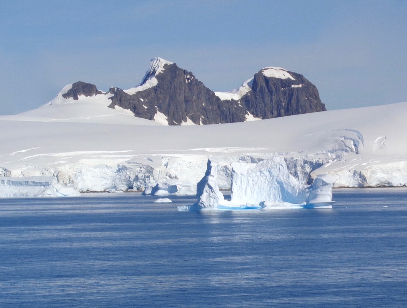
 But Antarctica is all of that – an austere beauty
 made up of a limited color
palette, with jutting shapes and angles and distant horizons. Blacks and greys, blues and
made up of a limited color
palette, with jutting shapes and angles and distant horizons. Blacks and greys, blues and  surprising aquas,
and more shades of white than I knew existed.
Clouds blow in, and suddenly the entire world is shades of grey and silver. Pointed cones of
surprising aquas,
and more shades of white than I knew existed.
Clouds blow in, and suddenly the entire world is shades of grey and silver. Pointed cones of  black rock, squared off ice
bergs looking like entire cities floating on the water. Everything perfectly reflected in the crystal
clear
black rock, squared off ice
bergs looking like entire cities floating on the water. Everything perfectly reflected in the crystal
clear  mirror of water in the calm bays, or churned by the wild waves of the
straits. It’s a silent world, except for
the occasional whale blow, or the scattered
mirror of water in the calm bays, or churned by the wild waves of the
straits. It’s a silent world, except for
the occasional whale blow, or the scattered  squawking penguin colonies, or the
cracks of loosening ice and the thunderous explosions as ice breaks off the
floating ice
squawking penguin colonies, or the
cracks of loosening ice and the thunderous explosions as ice breaks off the
floating ice  shelves.
 I’ve been trying to figure out how to include everything we’ve seen and learned on this part of our trip, and it makes the most sense to group things into the
 geology of Antarctica, the penguins (because I really like penguins, and we
also have one of the world’s best penguin
geology of Antarctica, the penguins (because I really like penguins, and we
also have one of the world’s best penguin  specialists onboard), and then whales
and seals.
specialists onboard), and then whales
and seals.We’re having a series of talks in the theatre but also simultaneously
 broadcast on
the ship’s television network, designed to prepare us for our Antarctic
Experience. These talks continue over
several days, on all the sea days
broadcast on
the ship’s television network, designed to prepare us for our Antarctic
Experience. These talks continue over
several days, on all the sea days  until we’re actually at the Antarctic
Peninsula, that long narrow peninsula that reaches up toward the bottom on
South America, and
until we’re actually at the Antarctic
Peninsula, that long narrow peninsula that reaches up toward the bottom on
South America, and  continuing on for several sea days after our time around the
Antarctic Peninsula.
continuing on for several sea days after our time around the
Antarctic Peninsula.We know that most of us will
 not be setting foot on Antarctica – this international
continent has a very delicate eco-system, and part of protecting the
environment is not allowing
not be setting foot on Antarctica – this international
continent has a very delicate eco-system, and part of protecting the
environment is not allowing  large numbers of humans to visit at the same time,
and very limited numbers of humans each year.
Only ships of less than 500 persons are
large numbers of humans to visit at the same time,
and very limited numbers of humans each year.
Only ships of less than 500 persons are  allowed to dock there, and only
100 passengers may be ashore from any one vessel at one time. So, our ship has several Antarctic experts on
board, who will lead us
allowed to dock there, and only
100 passengers may be ashore from any one vessel at one time. So, our ship has several Antarctic experts on
board, who will lead us  through our Antarctic Experience without taking us on
the continent physically. (But Richard
and I are still counting this as our seventh
through our Antarctic Experience without taking us on
the continent physically. (But Richard
and I are still counting this as our seventh  continent. We’re visiting it even if we aren’t stepping
a foot on the ice shelves – which, it turns out, aren’t even on the continent
either but are floating on the
continent. We’re visiting it even if we aren’t stepping
a foot on the ice shelves – which, it turns out, aren’t even on the continent
either but are floating on the  ocean all around the edges of the continent).
We crossed the 60 degree South line, putting us in the Southern Ocean and, according to our
 Expedition Team, in the Antarctic ecological zone. The Antarctic Circle is at 66 degrees 6
minutes South, and we only made it to 64 degrees 51 minutes S. So,
Expedition Team, in the Antarctic ecological zone. The Antarctic Circle is at 66 degrees 6
minutes South, and we only made it to 64 degrees 51 minutes S. So,  pretty close, and definitely in the
Antarctic zone.
pretty close, and definitely in the
Antarctic zone.These guidelines have been established by the initial twelve nations that created the
 Antarctic Treaty, in order to not only protect the environment but also to
ensure that this continent would be an international and
Antarctic Treaty, in order to not only protect the environment but also to
ensure that this continent would be an international and  peaceful site, and
that research would be cooperative and collaborative. The original Antarctic Treaty was signed in
1959, but there are now a total
peaceful site, and
that research would be cooperative and collaborative. The original Antarctic Treaty was signed in
1959, but there are now a total  of fifty-four nations that have signed the
treaty. (Twenty-nine of these nations
have active research going on at Antarctica.
of fifty-four nations that have signed the
treaty. (Twenty-nine of these nations
have active research going on at Antarctica.Our Expedition Team Leader is
 Dr. Bryan Storey, a retired professor of Antarctic
Studies and the first Director of Gateway Antarctica, the Centre for
Dr. Bryan Storey, a retired professor of Antarctic
Studies and the first Director of Gateway Antarctica, the Centre for  Antarctic
Studies and Research at the University of Canterbury, Christchurch, New
Zealand. His area of expertise is
geology, and he spent twenty-
Antarctic
Studies and Research at the University of Canterbury, Christchurch, New
Zealand. His area of expertise is
geology, and he spent twenty- four years as an Antarctic researcher. Dr. Craig Cormick is a historian and author
of over twenty historical novels and books of history, and has worked on
four years as an Antarctic researcher. Dr. Craig Cormick is a historian and author
of over twenty historical novels and books of history, and has worked on  several
Antarctic stations. Dr. Lloyd Davis is
one of the world’s top penguin specialists, and has written several books as
well as created a documentary film
several
Antarctic stations. Dr. Lloyd Davis is
one of the world’s top penguin specialists, and has written several books as
well as created a documentary film  “Meet the Real Penguins.” So, I would say we have quite an illustrious
team to prepare us and lead us through Antarctica! And, it turns out, Dr.
“Meet the Real Penguins.” So, I would say we have quite an illustrious
team to prepare us and lead us through Antarctica! And, it turns out, Dr.  Storey knew of my father,
who was a well-known coastal geologist, and whose hat is along on the
cruise. So the hat is very happy that
Dr. Storey is our expedition
Storey knew of my father,
who was a well-known coastal geologist, and whose hat is along on the
cruise. So the hat is very happy that
Dr. Storey is our expedition  geologist.
So first, a bit about the composition of Antarctica. Roughly 90% of the world’s ice is in Antarctica. Think about that
 for a
minute. Think about the various mountain
ranges covered in snow, ice, glaciers:
the Alps, the Himalayas, the Andes, the Rockies that run
for a
minute. Think about the various mountain
ranges covered in snow, ice, glaciers:
the Alps, the Himalayas, the Andes, the Rockies that run  the length of
North America, the NZ Alps, the Cascades, and random mountain chains that we
haven’t heard of. Add up all that ice,
and add in the Arctic ice.
the length of
North America, the NZ Alps, the Cascades, and random mountain chains that we
haven’t heard of. Add up all that ice,
and add in the Arctic ice.  And all of
that, added together, only makes up one-tenth of the world’s ice – the ice in
Antarctica is nine times more ice. I
find just that one little statistic
And all of
that, added together, only makes up one-tenth of the world’s ice – the ice in
Antarctica is nine times more ice. I
find just that one little statistic  absolutely staggering!
Antarctica is the 5th largest continent, being larger than Europe or Australia. Ninety-eight percent of the
 surface of Antarctica is covered in ice.
Antarctica is a continent of superlatives: most ice, coldest, driest, windiest, highest,
 deepest, and the most isolated. The
continent is literally a desert, with the central plateau getting less rainfall
that anywhere else on earth.
deepest, and the most isolated. The
continent is literally a desert, with the central plateau getting less rainfall
that anywhere else on earth. The
deepest continental canyon is in Antarctica, at 11,000 feet (just over 2 miles
deep, twice as deep as Grand Canyon) – roughly 3.6 km deep.
The
deepest continental canyon is in Antarctica, at 11,000 feet (just over 2 miles
deep, twice as deep as Grand Canyon) – roughly 3.6 km deep.  But keep in mind that that canyon is covered
in ice. In fact, some of the land mass
of Antarctica is below sea level, but is covered with enough ice that is forms
part
But keep in mind that that canyon is covered
in ice. In fact, some of the land mass
of Antarctica is below sea level, but is covered with enough ice that is forms
part  of the continent.
The Polar Plateau is 15,665 feet (4.77 km) of ice – nearly 5 miles of ice. This is an ice sheet, which is what geologists
 call the ice that is on the land mass. The ice that surrounds the land, floating on
the ocean, is referred to as ice shelves.
And yes, the ice shelves
call the ice that is on the land mass. The ice that surrounds the land, floating on
the ocean, is referred to as ice shelves.
And yes, the ice shelves  are what break off to form ice bergs.
The magnetic or geographic pole, the actual point where the southern axis is located, is at the Amundsen Scott
 station, named for two explorers who were in
a race to reach the actual magnetic pole.
(Amundsen got there before Scott.
Also, Amundsen’s team
station, named for two explorers who were in
a race to reach the actual magnetic pole.
(Amundsen got there before Scott.
Also, Amundsen’s team  survived; Scott’s did not.) However, because the ice sheets move, as
glaciers tend to, the US research team re-surveys each year to re-establish the
true South Pole – and
survived; Scott’s did not.) However, because the ice sheets move, as
glaciers tend to, the US research team re-surveys each year to re-establish the
true South Pole – and  they put another pole in the ice. (They don’t remove the previous poles,
because this also shows some of the shift of the ice.) At the true
they put another pole in the ice. (They don’t remove the previous poles,
because this also shows some of the shift of the ice.) At the true  South Pole, the ice depth is 9000
feet – just about 3 km.
South Pole, the ice depth is 9000
feet – just about 3 km.You can start to understand why 90% of the world’s ice is in Antarctica!
 The
continent is vaguely bisected by the Trans Antarctic Mountain Range, and the
two halves of Antarctica are referred to as
The
continent is vaguely bisected by the Trans Antarctic Mountain Range, and the
two halves of Antarctica are referred to as  East and West Antarctica. Not that any of the compass directions really
have any bearing when one is at the South Pole, because everything is basically
just
East and West Antarctica. Not that any of the compass directions really
have any bearing when one is at the South Pole, because everything is basically
just  north. But the uneven halves are
either mostly in the eastern or western hemispheres, and it just seemed like a
logical way to help describe and orient
north. But the uneven halves are
either mostly in the eastern or western hemispheres, and it just seemed like a
logical way to help describe and orient  different locations on Antarctica.
The Trans Antarctic Mountain Range has mountains as high as 14,865 feet – just about
 4 km. As the ice sheets shift and
move in a somewhat circular fashion, the ice tends to rise up along the lower
edges of the mountains,
4 km. As the ice sheets shift and
move in a somewhat circular fashion, the ice tends to rise up along the lower
edges of the mountains,  and whatever is under the ice slowly rises to the top
and is exposed. So centuries (eons?) of
meteorites have been exposed this way, and are
and whatever is under the ice slowly rises to the top
and is exposed. So centuries (eons?) of
meteorites have been exposed this way, and are  concentrated along the edges of
the mountains. Research into the
geological composition of these meteorites has been able to identify where
concentrated along the edges of
the mountains. Research into the
geological composition of these meteorites has been able to identify where  they
came from originally – and yes, some of these meteorites have come from various
planets in our solar system, as well as the moon!
they
came from originally – and yes, some of these meteorites have come from various
planets in our solar system, as well as the moon!The Polar Plateau is the coldest place on earth, with recorded temperatures up to minus 100 Celsius. I don’t even know how cold that would be in Fahrenheit – some 200 below zero I think. ACK! (I had to look it up, just for accuracy. The annual average temperature of Antarctica, Ridge A, is -70 C (or -94 F). The coldest recorded temperature in the entire world was at Vostok Research Station, in July 1983, with a low of -89.2 C (-138.6 F). I suspect the -100 C is a more recent reading than what I have in my mini atlas.)
The air circulating around the pole is cooled by this Polar Plateau, and the changes in air temperature create high winds called the Katabatic winds. Hurricane speed winds. Crazy strong and crazy cold, all at the same time!!! And those winds, plus the cold, combine to prevent appreciable rainfall in the central part of Antarctica, making it a desert.
That wind and desert conditions have created the McMurdo Dry Valleys in parts of the mountain range – and the dry valleys are slightly warmer, almost sandy valleys with no ice, other than the occasional glacier that creeps through a mountain pass and tries to climb down into the valley. These glacial fingers tend to melt, and there actually are one or two rivers and lakes in the dry valleys.
There are 372 lakes BELOW the ice sheets on Antarctica – yes, fresh water under those miles and kilometers of ice! Various microbes have been found in the few lakes that have been researched (by drilling through all that ice, and taking samples). The microbes have led researchers to believe that the water, or the microbes, reflect the atmosphere from 43,000 years ago!
Scientists have names for all the different kinds of ice – and the ice moves from the center outward toward the sea. Glacial ice over the land mass of Antarctica is sheet ice. Ice that moves over the ocean around the land, and Is literally floating on the water, is shelf ice. If it’s still attached, it’s referred to as fast ice. And ice that breaks off the shelf ice is what we call icebergs. Of course, there are different names for icebergs, depending on their size and shape. Icebergs over 2 km (about 1.2 miles) are named with a letter and number; the latter is based on what quadrant the ice broke off of Antarctica. As most people know, roughly 7/8 of an iceberg is below the surface of the water. I found the tabular ice, the very squared off and linear ice that breaks off the ice shelves, to be the most fascinating. They are HUGE, and look like giant cities frozen in one solid rectangle of ice, in some weird science fiction sort of way!
When you look at the tops of some of the ice and snow covered peaks, especially the steep ones, they look ridged, sort of like giant forks were dragged through the snow. This shows relatively recent avalanches, where the snow, ice, maybe boulders were indeed dragged through the snow as they thundered down the slopes onto the ice sheets, ice shelves, or even into the water below.
Antarctica is so cold in winter, the sea water actually freezes. Sea ice is literally frozen ocean water, and there are various kinds of sea ice. But we’re hoping to avoid all of it!!!
That was pretty much our first talk on the geology of Antarctica.
Now, there is a long history of exploration of Antarctica, and it’s a rather sad history. Our history author on board, Dr. Craig Cormick, gave a short summary. I’ll summarize even further, not being much of a historian.
Basically, once European and North/South American countries realized that there was an actual continent covered in ice far to the south, various countries competed to be the first to actually reach the continent. Among explorers and sailors, it became a point of pride to be the first to reach the continent. Attempts were made, and many failed. Ships sank, or the entire ship was caught in the winter ice, and everyone on board perished. Or the ship landed on an outlying island, and the explorer wrongly claimed to have reached Antarctica. Some explorers outright lied about having reached this isolated continent.
Once actual footsteps were made on Antarctica, then it became a competition to see who got there first. Who made it farthest south. Who sailed all the way around Antarctica. Who walked across Antarctica. Who found the magnetic South Pole. Even who had the first baby on Antarctica (yes, some women accompanied their husbands on these explorations), and then who conceived the first baby that was born on Antarctica. (It got rather silly, in my opinion. You can tell, since I didn’t keep copious notes on who first did what, and who should get the credit.)
One of the best known explorers was Shackleton. While he didn’t really reach his goals of exploring Antarctica, he did manage to rescue all the men on his ship after the ship broke apart while being frozen in the sea ice. It was a long and involved rescue, with three aborted attempts – but he didn’t give up, and on the fourth ship he managed to save every man who had originally sailed with him.
Another well-known scientist to travel through this region was Charles Darwin. Everyone thinks of him as focusing on the Galapagos, but he only spent a few months there. On his voyage of the Beagle, a five year trip, he spent over 3 years sailing and exploring around Central and South America, including sailing around Cape Horn. His time in this part of the world, including the Falkland Islands, added to his vast knowledge of natural science and animal biology, including time finding fossils of huge animals that were related to living animals still in the world today. All of this study and understanding eventually led to his theory of evolution and adaptation of animals, as well as the concept of survival of the fittest.
Back to the geology. We had several talks about the geology of Antarctica, and there were a number of items that were interesting. Facts that make one wonder why we’ve never even heard of this previously. Science that definitely came about after I was in school, decades ago. And I know this is a long blog post, but this helps us understand the continent.
Way back in the early history of the Earth, some 1000 to 750 million years ago, the land mass was one giant supercontinent that scientists call Rodinia. Roughly 550 to 180 million years ago, Rodinia broke up into two large continents, Pangea vaguely in the northern hemisphere, and Gondwana in the southern. And then some millenia later, about 183 million years ago, Gondwana (and likely Pangea) broke up into separate continents that eventually formed the seven continents we know today. (Subcontinental volcanic activity led to this major geological event.) These continents are attached to the tectonic plates that form the Earth’s crust. The tectonic plates cover the magma, molten rock, that surrounds the Earth’s core.
As the plates move and shift, sometimes spreading apart, sometimes overlapping, different geologic events can happen. Earthquakes and volcanoes are prime examples. When the plates spread, some of the magma rises up under the oceans and becomes basalt, an igneous rock. Then, where plates overlap, the plate underneath can push up part of the upper plate, all the way to the surface. This is referred to as subduction, one plate sliding under the edge of another plate.
So this is what happened to form the Antarctic Peninsula, and why we find igneous rock there. Well, also granite, which is a metamorphic rock – rock that was either igneous or sedimentary, but that changed under tremendous pressure. Some of the mountains that make up the peninsula were once volcanic, and there are a few islands that still are considered active volcanoes. But most are considered extinct. And there are towers of basalt, where any surrounding rock has eroded away from the volcanic core, leaving these basalt pinnacles.
Also, the Trans Antarctic Mountains are the edge of the West Antarctic Rift, which formed about 45 million years ago. There are still four active volcanoes there, and this rift also formed the deepest part of Antarctica.
Fossil evidence shows that Antarctica was once covered in ocean, and then later on in lush plant life, and dinosaurs roamed the land. This fossilized evidence also shows which continents were originally next to what other continents way back when the land was Rodinia, and later Gondwana and Pangea. Every school child can see that South America and Africa fit together like puzzle pieces – but part of Antarctica and the southern edge of Australia also fit together. Antarctica was once attached to South America, but that land bridge was eroded and the Southern Ocean was formed.
Once that Southern Ocean began to circulate around Antarctica about 35 million years ago, tropical currents were blocked off and Antarctica began to cool. More and more ice began to build up, until about 15 million years ago the glaciers were pretty much established, and the following millenia only added more ice to Antarctica. Until our recent recognition of climate change, anyway.
That’s just a very brief summary, but it helps to understand how the land was formed.
And for the scientists among our readers, I hope I’ve gotten all of that right. I like to be accurate, but I’m not a geologist. It was pretty fascinating, though.
And for the artists and poets, all that geology made Antarctica a very unique and beautiful place!
Maps of Antarctica, both ice and the land under the ice, will be at the very end after all the photos, as well as a map of the route we took and places we visited. I'll include our map for each blog post about time in Antarctica.


Our trip is marked in the upper left corner, along the Antarctic Peninsula and the nearby islands.


No comments:
Post a Comment