 Days 24-25 or something -
 Driving Along the Volcano Highway
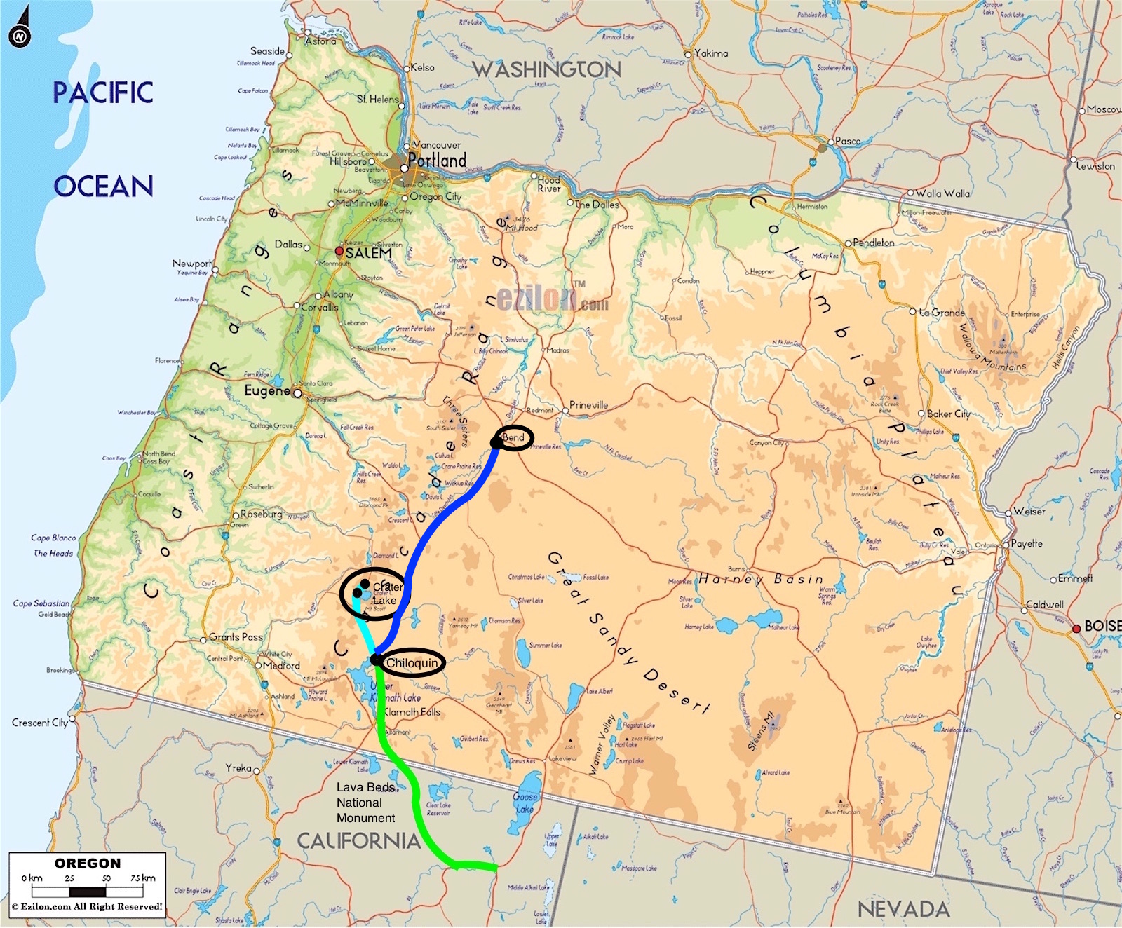
We drove to the Crater Lake area,
 and stayed in the small town of Chiloquin. This part of Oregon was once inhabited by three Native American nations: the Klamath
  (pronounced KLAM-muth), the Modoc (pronounced MOE-doc), and the Yahooskin (pronounced yah-HOO-skin).
 As always, there
 are Native American myths and legends surrounding natural phenomena, and the story of the formation of Crater Lake is
  wonderful.
The Klamath legend is something like this:
There were Great Spirits of the earth and sky who came and
 talked with the people. Llao, the spirit of the Below-World, lived beneath Lao-Yaina (Mount Mazama, which was the volcano that became Crater Lake).
  Skell was the spirit of the Above-World. Before the creation of the lake, Llao would pass through a hole on the top of Lao-Yaina and stand there on
  the mountain, looking at the outside world, his heading touching the stars near the home of Skell.
 One day, Llao saw the beautiful
 daughter of the Klamath chief, and fell in love with her. The young woman, Loha, rejected him because he was ugly, and he was from the Below-World.
  Llao became angry and swore that he would take vengeance on her people. He tried to destroy the Klamath people with fire. The Klamath chief sought help from
  Skell, spirit of the Above-World.
Skell came down from the sky to the top of Mount Shasta. Skell and Llao began to battle in the way
 of the spirits, throwing huge red-hot rocks back and forth at each other, from Mount Shasta to Mount Mazama. They caused huge landslides, and the earth thundered and
  trembled under their great power.
A terrible darkness spread of this region, and lasted for days. All spirits
 of earth and sky became involved in this battle, and the humans living here were very frightened by the spirits fighting and causing the earthly chaos.
To appease the volcano gods and atone for the sins of the Klamath nation, two medicine men sacrificed themselves by jumping into the pit of the Below-
 World. Skell was impressed by their heroisim, and fought even harder. Skell finally defeated Llao, who retreated deep down into the
  Below-World. Skell collapsed the top of Mount Mazama to impression Llao beneath the world forever, so that he would no longer be able to harm the
  people. Skell wanted peace and tranquility to cover up the dark pit he created, so he filled it with beautiful blue water.
The lake was called Giiwaas (a
 most sacred place), known as a place of power.
 The Umpqua nation have a similar legend, although the spirits have
 different names.
Isn't that a wonderful story? So much more poetic than the scientific explanation. But yes, I'll include that as well.
 Mount Mazama was a huge volcano that dominated the landscape. It stood about 12,000 feet (nearly 2.3 miles, or 3.6 km!). It
  erupted approximately 7,700 years ago (yes, about the same time as the Lava Beds National Monument eruptions - and I can't find any information
  about whether the two major eruptions were related or not).
 Mount Mazama was a composite volcano, formed slowly over about
 half a million years, built up a bit every time it erupted and lava flowed down the sides. But that cataclysmic eruption about 7,700 years ago
  destroyed the mountain.
It began with a blast of rock and ash. New vents or fumaroles encircled the peak, bringing steaming hot flows of pumice,
 ash, and gas down the sides and into the surrounding landscape, creating valleys and filling river beds.
So much of the
 magma chamber inside the mountain was emptied so quickly, the volcano no longer had internal support. The mountain basically collapsed inward,
  creating the huge caldera or crater that became the lake. Later eruptions sealed the caldera, and centuries of rain and snow melt
  filled the basin with clear, pure water.
 The ash and pumice that created the valleys and filled the riverbeds has somewhat eroded, creating
 an eerie landscape of igneous rock towers, fingers, barren hills, and random rocks lying strewn across the land.
 The information signs around the lake included this description of the island in the middle of the lake:
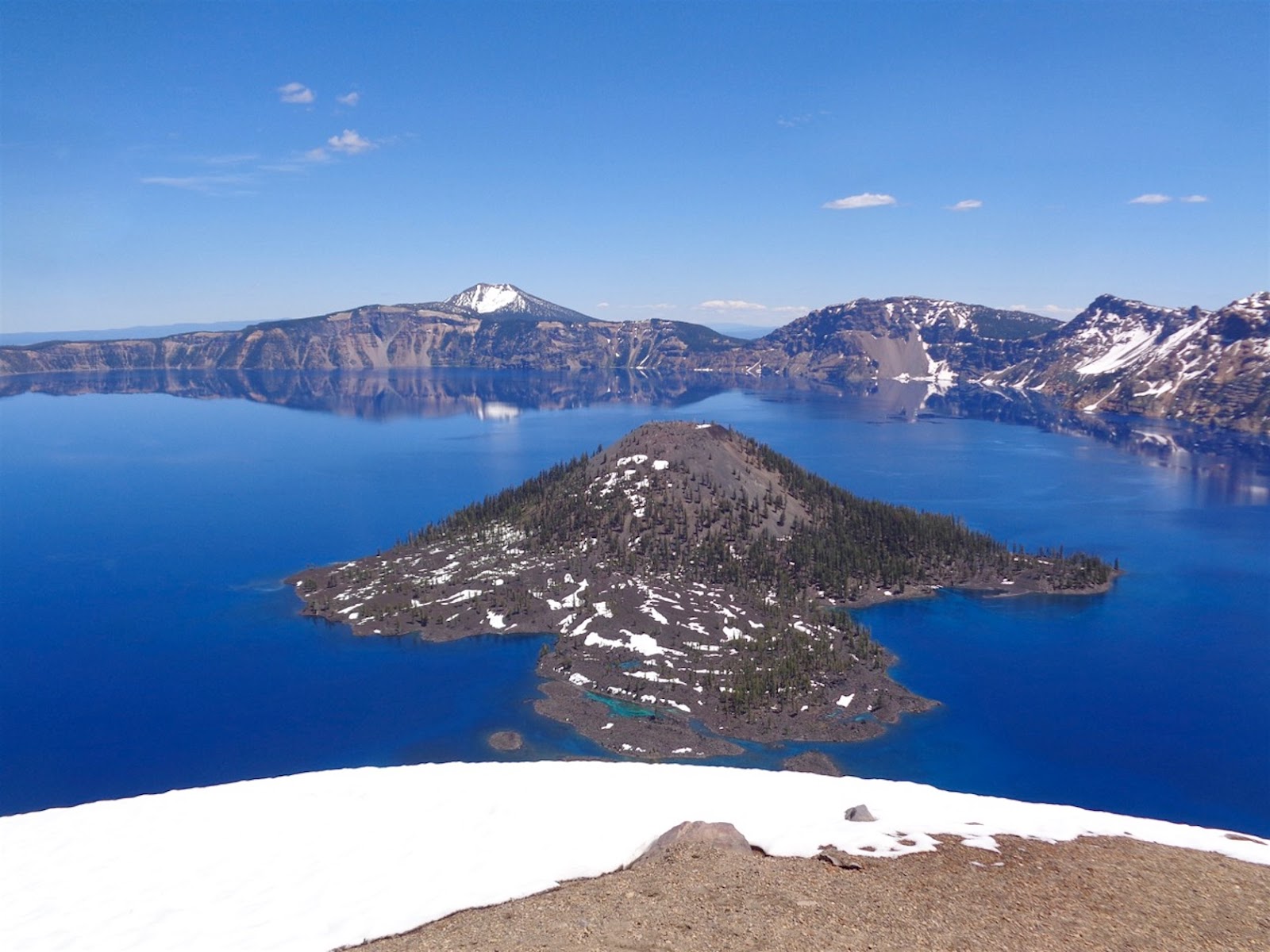
"Wizard Island, the small volcano within the lake, is a cinder cone formed during this time as magma erupted into the air, cooled quickly, and fell as cinders. A small crater rests on its summit. Magma also erupted under water, forming smooth pillow lava. A second similar volcano, Merriam Cone, is hidden from view beneath the lake. Future eruptions may bring further change to this landscape."
And Wizard Island is named for the shape of the cone, similar to a wizard's hat. While it looks like Professor Dumbledore's hat, the name of Wizard Island came long before the Harry Potter books and movies.
Some facts and figures - The lake surface elevation is at 6,173 feet (1.88 km). The elevation of the lake bottom is at 4,230 feet (1.29 km). And the former top of Mt Mazama was roughly 12,000 feet (3.7 km).
The maximum depth of the lake is 1,943 feet (592 m), making it the deepest lake in the USA, and the ninth in the world. While Crater Lake isn't perfectly circular, it is somewhat round - and the maximum distance across is 6.1 miles (9.8 km). HUGE!
The surface area of the lake is 20.6 sq miles (or 53.4 sq km).
Water temperature near the surface ranges from 32 to 60 F (0 to 16 C). However, about 260 feet (79 m) below the surface, the temperature is about 38 F (3 C) year round.
Crater Lake is known for it's clarity; visibility is 143 feet (44 m), a world record.
"Why blue? Longer wavelengths of sunlight (red, yellow, and green) are absorbed by the water. Blue light is not absorbed by water well. It strikes the water and is scattered and redirected back from the lake depths to our eyes."
The deep deep sapphire blue of Crater Lake seems almost impossible. Really, the color is incredible. The lake almost glows from within.
Dad's hat and I had a wonderful time driving part of the way around the lake. Well, first we drove up there, through the valley, stopping at a scenic viewpoint to look at the remainder of Mount Mazama. This is the rim of Crater Lake, and it's so high up it sticks up beyond the surrounding foothills.
Then we drove through the surrounding forest, full of Ponderosa pine trees. The region borders the high desert part of Oregon, even though the mountains are technically part of the Cascade Range. But Crater Lake is on the east side of the Cascades, so the area isn't as wet and rainy as the western side.
There were signs for deer and elk, and I saw one young doe in the woods. And in the campground, there were signs about bears, and warnings to keep food in sealed containers, not open in your car. I didn't see any bears, though.
So. There are two major entrances to Crater Lake, and we drove in from the south. Fortunately, the road on the west rim lwas open, and I drove most of the way to the north entrance. The road on the east rim was still closed due to snow. In fact, the west road had only been opened for a week or so. I could believe it - there were areas on the drive where the snow cut away off the road, and was maybe 8 to 10 feet high! (About 3 meters of snow!) In other scenic overlooks, the snow was piled up by the plows.
Many of the trails were still closed with all the snow, as were some camping areas in the neighboring areas. But people were able to drive from the north to south entrances, and the various vista points were mostly open. We could walk around the paved areas, and even up some of the hill trails right off the overlooks. Other areas were a bit wet or muddy from the snow melt.
And it was COLD!!!
But so gorgeous. I stopped at maybe five or six overlooks, and hiked around with the hat, marvelling at the incredible views of this unbelievably beautiful lake. That impossible blue reflecting the sides of the caldera, the remaining snow scalloped on the edges of the lake, the green green trees softening the harsh landscape of the rim. And chubby little chipmunks, and chubbier striped ground squirrels, running around and amusing the people looking on. Some snowy white flowers were also blooming around the edges of the retreating snow banks, adding to the mysteries of this not-quite-on-earth place.
Crater Lake is absolutely worth a visit, even a special trip. There's a peaceful aura surrounding the lake and region, even with such a violent and earth-shattering creating and past.
But definitely stay behind the walls and fences. Apparently someone slipped and fell just a few days prior to our visit, and while they survived, well, I wouldn't want to fall some 800 feet (244 m) into a caldera full of rocks and freezing cold water! Yeah, not smart. And the views are great from right at the walls!
If you need more information, here is the Crater Lake National Park website: www.nps.gov/crla/index.htm. Go. Definitely one of the more beautiful spots in a truly gorgeous corner of the USA.


No comments:
Post a Comment