 Day 8 - We left Arcata bright and early, and did our usual heading south on Pacific Highway 1, no
  specific destination in sight.
But along the way, there was a sort of detour to the Avenue of the Giants! How could we resist?
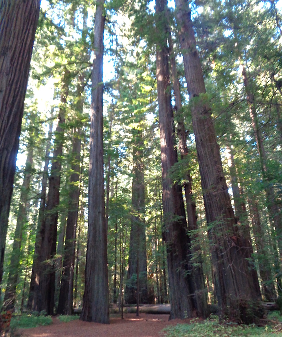
The Avenue of the Giants is a self-drive car
 tour through a series of redwood groves and forests that make
  up the Humboldt Redwoods State Park. There are maps and small brochures people can pick up to identify where they are going, and what
  they are seeing as they drive along amidst these
  magnificent trees.
Not only were we seeing the huge redwoods - now we were seeing Sequoia Sempervirens - the sequoia trees, commonly known as Coast Redwoods. These amazing trees are taller than any other single living thing in the entire world!!!! The sequoias are the redwoods that can live over 2000 years! And they can survive forest fires and flooding!!! Absolutely incredible trees. Plus some of the groves we drove through are virgin forest (meaning they've never ever been logged).
As we drove along, we'd talk about these huge and majestic trees. I mean, think about living for 2000 years in the same place. Do trees think? Do they feel? Do they realize that the world around them is changing when roads come through? Did the original people who lived among these trees revere them? Does it tickle the tree to feel squirrels running up and down? Do the trees understand birds singing or chattering in their branches?
Tree philosophy.
We had a wonderful time driving along and stopping to see the trees. Talking to them, giving them occasional pats or hugs, and breathing in the wonderful redwood perfume.
Some of the trees even had faces somehow grown into the tree. These were probably random burls and growths, but they often looked just like the face of the tree. Adding, of course, to our anthropomorphising of the trees.
Eventually, we left the Avenue of the Giants, and continued on south. Nothing else that day matched the magnificence of the redwoods. We ended up staying in Fort Bragg.
And I know there are a lot of extra large photos here, but it's the only way to really see and feel how huge these trees are in a photo.

 Day 9 - We continued south the following morning, stopping at various scenic overlooks.
  Although here in California they seem to be called vista points.
The rocky coast continued, with headlands jutting out and scattered rocked rising
 from the sea. As Richard said, they look like an armada from a distance.
We occasionally would see whales - not close enough to see
 the actual whales, or any flapping tails. But close enough to see two or three whales clearing their blowholes as they
  migrate south for the winter.
We also drove through small small towns. I mean, towns with maybe 170 people living there. Tiny little towns.
Our favorite town was Elk. Mostly because there was an Elk Store, where we speculated that you could buy an
 elk. (Not really, they had great food and coffee, as well as
  sundries and groceries.) Nearby was the Elk Garage, where yes, obviously, you could get your elk repaired. It was funny to play with the names of the businesses and just get silly with it. But Elk really was a cute little town, with buildings dating back to 1902 and 1927 or so.
Some of the gardens or landscaping in front of the shops had beautiful flowers. But I was most intrigued with some succulent plant that looks something like a jade plant, but the leaves grow in rosettes. I've asked at a few places, but no one knows what these plants are called. I just found them absolutely fascinating!
We spent the night in Gualala. We had no idea how to pronounce this, so I asked. The local pronunciation is gwah-LAH-lah. It's a Native American name (my source wasn't sure specifically which nation, but indigenous to this part of California). And the name means something like "fresh waters running down to the sea." A lovely poetic way of describing a region with rivers that run to the ocean.


 Day 10 - More driving south along the Pacific Coast Highway 1, with gorgeous views, dramatic coastlines, and
  scattered redwood groves.
 Really, the trees would be clustered together along the road. We'd be merrily driving along, and
 suddenly we'd go around a turn and find ourselves in a dark tunnel of trees! Redwoods towering overhead, blocking out the sun and creating
  a corridor below their branches, with us driving through with our headlights on, just to be able to see the dashboard gauges! More redwood perfume in the air, and that soft muffled quiet surrounding us.
Occasionally we'd drive through a grove of eucalyptus trees - peeling bark, curling leaves, and their slightly medicinal scent. Wouldn't it be nice to have some koalas come over from Australia and live in the eucalyptus trees of coastal California? I'd certainly be happy to see some koalas living here!
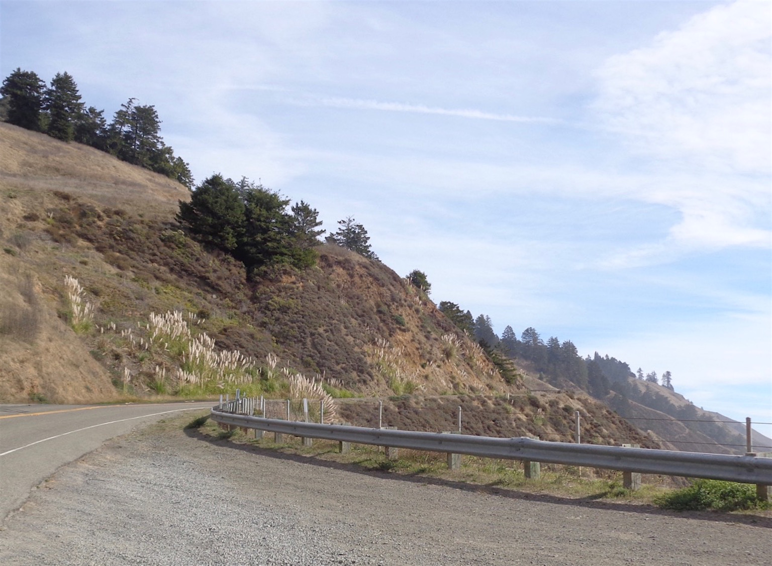
The hills in this area have pampas grass, the huge feathery fronds we saw growing all over Patagonia in the Argentinian side. No idea if this grass is native to this region, or imported from the Pampas region of Argentina. But such an elegant and beautiful contrast against the rugged rocks of the coast.
The highway seems to come and go at times, sharing the road with other highways. Or maybe we just occasionally would lose it. We somehow made our way to Petaluma, a bit more inland, and spent the night.


 Day 11 - We made our way to San Francisco. The morning was sunny inland, but the fog blew in
  and smothered the Golden Gate Bridge. We drove across and could only see the structure immediately around us - could barely see 20 or 30 feet (7 to 10
  meters) in fron of us! On the other hand, it meant we also couldn't see how high up the bridge really is, since the entire area between the bridge and the
  bay was filled with fog.
Just so San Francisco!
We drove up and down hills and got a bit lost getting to our
 hotel - but in our defense, it was the fault of the cable cars, which have their own traffic lights and turns. It makes it rather confusing for someone who isn't used to the system. After our second time around the block, we managed to find our hotel, and settled in.
On the map at the end, you can see that Petaluma is only a very short distance north of San Francisco. We planned it that way so I could meet up with a friend in SF - at Ghiradelli Chocolate, of course. Amazing chocolate, and we were good and shared a small item.
Throughout the day, I'd periodically get more photos of the Golden Gate. By evening, the bridge had finally emerged from all that fog, and could be seen in the distance.
And yes, there were people swimming in that water! San Francisco is almost always chilly and either foggy or wet - so I was walking around in a jacket. I cannot imagine swimming in the water - it must have been barely 50 degrees F! (That's maybe 10 C - that is COLD!)
We never managed to get our cable car ride, but we enjoyed our very brief return to a city we've both enjoyed for years. Somehow, San Francisco has a charm all its own, a feel very different from other cities.
We definitely need to come back and spend more time here!


 Day 12 - We left San Francisco, getting vaguely lost again. More steep hills, zigzagging through one way
  streets to the Embarcadero. Amazing how the names of the streets come back, even after some forty years.
We stopped at Half Moon Bay,
 because it has always sounded so romantic and iconic. Turns out that Half Moon Bay is a huge crescent-shaped beach, with dunes covered in succulents, and waves crashing on the shore. We wandered around the dunes a bit, but couldn't find the paths down to the beach. Dad's hat enjoyed this beach, though, and had fun ambling around the dunes.
The redwoods continued, as did the eucalyptus. There are other trees mixed in, but these two are the most recognizable.
We drove through Castroville, apparently the world capital of artichokes. Really, complete with a giant artichoke statue. Then somewhere near Salinas, the city where the songster let Bobbie McGee slip away, we spent the night.
 Day 13 - Spent the day driving through the Big Sur area. I've never been sure exactly what Big
  Sur is - on maps, it looks like a large point of land sticking out into the ocean. But this is another beautiful region where there are few towns or houses,
  mile after mile of rolling hills alternating with more redwood groves, scattered eucalyptus, and scenic views of the ocean. Blue blue sky, green green trees, and open spaces.
 Big Sur was big in the 1960s and 70s, although the area still is full of big
 open spaces. Unspoiled nature and fresh air, which is always wonderful.
But there are now a couple of areas with restaurants, small local hotels or cabins to rent, and hiking trails abound.
We stopped at a few vista points at the top of hills, and every time the wind was absolutely insane! I mean, it truly was a major struggle to open the car door and NOT have it go flying out of my hand (and possibly flying off of the car!). And then getting back into the car while holding the door, again to be sure it didn't blow off??? Insane!!!! I took a selfie with my hair blowing, just to show how crazy wild that wind really was!
We made our way to San Simeon, a small town made famous by the San Simeon castle built by William Randolph Hearst. We didn't visit the castle, but found a quiet little hotel right by the beach. Love falling asleep to the sound of waves in the distance.


 Day 14 - Today, we continued south as usual. Pacific Highway 1 came and went - really, it kept
  disappearing! Sometimes it would share the road with another highway, and both signs would be posted. But at other points, well, it was just gone. We did our best, but were SO happy we had our handy road atlas so we could somehow find our way to Santa Barbara.
 I hope the map shows up well for you. It's hard to get a decent map of California, because it's such a long state. But remember, you can click on a photo and enlarge your view on your computer!

Thanks for sharing your brownie sundae!
ReplyDeleteAnd thank you!!!!
Delete