Thursday, December 16, 2021

Pandemic Diaries - Year 2, November

16 December 2021


In mid November, we drove over to Las Cruces, New Mexico, for a short visit.  I know, that was about a month ago - it took me that long to finish uploading the photos and writing the blogs about our drive to Arizona.  So to resume, we went to Las Cruces.


The eldest of my three brothers lives in Las Cruces, and Richard's old college buddy (F) and his wife (J) are wintering in Santa Fe, NM.  Turns out Las Cruces is just about halfway between Tucson and Santa Fe, so it seemed like a good place to meet up.


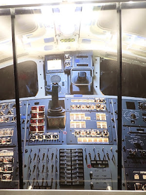
We found a nice hotel near the oldest part of the city, and met up with my brother for our first night.  We knew the next few days would be busy exploring the region with our friends.  Turns out they came to the same restaurant we picked for dinner!!!  It was funny and unexpected, but we made plans to meet up the next day.


It isn't always easy coordinating four adults, but we agreed a drive vaguely north to Alamogordo and the White Sands National Monument sounded like a good thing to do on a somewhat cool but sunny day.


Turns out that Alamogordo is home to the New Mexico Museum of Space History, which not only explains how this area became vital to the US space program, but also houses the International Space Hall of Fame.  


This museum ended up being much more fun that I had imagined.  There were many interactive exhibits, and while there were detailed explanations, many things were geared to involve children in learning about space exploration.  

Just for starters, the two elevators looked like the entrance to some of the space ships.  And inside each elevator were images of the control panels for, well, whichever space ship.  So of course J and I started pretending we were flying the space ship as we rode to the top floor, pushing buttons and the throttle and making zooming noises.  


There were various capsules and space suits, all kinds of technical information about the race to space, the propulsion of space ships, and one thing that confused me, using gyroscopes to navigate.  (Because once in space, a compass won't work.)


The most fun things were flight simulators!  J and I had a great time - we both crashed the space shuttle on our first try as it was returning to Earth, though my second attempt was more successful.  Then there was the simulator to land a probe on Mars (I crashed), and then looking for the probe while bouncing around on Mars.  (I kept crashing into a Mars boulder.)  Our husbands were less hands-on, but J and I had a good time, even if we both crashed several times.


Anyway, if you're interested in space exploration, this museum really is worth the visit.  There also was one whole section on how the TV show Star Trek kept abreast of developments with NASA, and how some of what we saw on the show eventually became reality!  ("Fascinating," in a deadpan Spockian voice.)


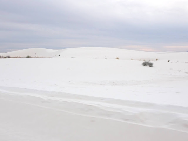
A quick lunch, then we headed back toward Las Cruces so we could go to White Sands National Park.   This was fascinating, even though the temperatures had dropped a bit and the sky clouded over.


White Sands is one of those weird natural phenomena that happen rarely, because all conditions must be present and set up in perfect sequence in order to make things happen.  Kind of in the middle of nowhere, except the White Sands Missile Range is also there, but that's beside the point. 


So, White Sands is a 275 square mile (or 712 square kilometers) field of white gypsum sand crystals.  This isn't regular sand, like on beaches - this is soft and powdery, and white like snow sand.  During rainy season, the water runs through the nearby mountains and dissolves the gypsum in the rock.  This dissolved gypsum and rain runs off into the Tularosa Basin, and forms a lake during this time.  Eventually, the water evaporates, leaving gypsum crystals behind.  The desert winds blow against the fragile crystals, which break apart and rub against each other, eventually turning into the powdery sand-like substance that forms the huge dunes.


There are various animals living on and in the dunes, and these animals have adapted to this very unusual environment.  Some animals have actually changed their coloration so they can more easily hide from predators in this white white white environment! 


All that information, and more, came from the visitor's center, so definitely stop there.  They have a film that explains everything, as well as a nice gift shop.


Interesting, and pretty much the only place like this on earth!  For more info, here's the park's website:  https://www.nps.gov/whsa/index.htm 


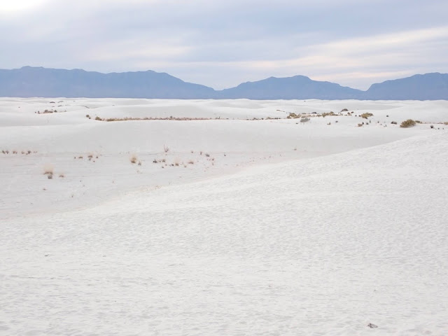
The outer edges of the huge dune field had various grasses and desert plants like yucca and agave.  The plants help to stabilize the dunes, although the shapes and sizes of the dunes constantly change due to wind, rain, and people running or sliding down the dunes. 


We drove around, first on tarmac roads, and and then on roads that were packed gypsum sand.  It really was like driving around on snow, without the sliding on ice effect.  We parked at a couple of places so we could walk on the boardwalks over the dunes, and look at all the plants.  Didn't see many animals except some birds, and one large dead beetle.


We did climb up a few dunes, and from the top it's like looking across rolling hills of snow.  Really, it's that white.  Totally other worldly.  Quite a few movies have used White Sands as alien or outer space locations, and this national park really does have that feel.  It really is a strange, almost eerie place, especially as the day became more and more grey.


The most disorienting part was that yes, initially the dunes look like regular beach dunes.  But then, there are blue-purple mountains in the distance.  And somehow, craggy mountains and sandy dunes don't quite go together in our human experience.  In some of the photos, the bluish mountains actually look like the ocean in the distance!  I know it really isn't the ocean, but I think our brains are so used to sand and ocean going together, we unconsciously pair them and so we see what we THINK we should see, not what we actually are viewing!  Totally disorienting!


Of course, the other part of my brain kept whispering "snow!  It looks like snow!"  This while I was climbing hills and dunes of "snow" in my bare feet.  Another moment of confusion because somehow, this just didn't quite compute!


If you ever get a chance, go here.  Seriously, it was fun and confusing and weird and absolutely worth it!   (Lots of photos, but more narrative after them.)


Our second day, we explored Mesilla (pronounced meh-SEE-yah), the older town almost merging with Las Cruces.  Most of us think of this part of the US as being taken over or stolen from Mexico after the war with Mexico in the 1800s, but this region was actually purchased as part of the Gadsden Purchase.  In 1854, a detachment from Fort Fillmore first raised the US flag here.  Four years later, the Butterfield stage coach began its run through Mesilla.


Mesilla was the capital of the Confederate Arizona Territory, which encompassed modern-day Arizona and New Mexico.   Yes, the Civil War reached all the way to the US southwest, and this region sided with the South.  There were actually two battles of Mesilla involving the troops at Fort Fillmore.  Neither battle was decisive, but they are definitely remembered locally.  (This is one of those things that most of us never learned in US history in school!)


Billy the Kid is probably the most famous (and notorious) citizen - he was sentenced to death at the county courthouse, and the building is still standing (with a sign to mark the location).  Billy (or Kid) was tracked down and killed by local hero Pat Garrett.  However, later on Garrett was mysteriously murdered in an arroyo not far from Las Cruces.  He's buried in a local cemetery.


A bit gruesome, I know, but such was life in the Old West.  One building had a sign telling story about the man who ran erected that building which housed his business.  He was murdered, and a relative took over the business.  He was murdered, and another relative took over.  Several relatives were killed in similar ways, then some business partners.  I lost track of how many unlucky businessmen died in that one location.


But there was a pretty church that dated back to 1851, although the present building was put up about 50 years later.  There's a lovely park with pecan and pistachio trees, both nuts grown in orchards throughout the region.  The buildings are 100 to 150 years old and are colorful, and there are interesting shops to browse as well as tasty treats to eat.


We moseyed in and out of shops, sat in the park enjoying the sunshine, and nibbled on some of those treats.  It was a nice way to spend our morning.


In the afternoon, we drove out to the New Mexico Farm and Ranch Heritage Museum.  This was more interesting than it sounds like - the building had displays that gave information about farming and ranching, both history and technology.  But this was also an interactive museum, with barns and animals and corrals.  It was a beautiful sunny afternoon, so J and I walked all over to visit the sheep, cows, and horses.  


Unfortunately, the interactive part didn't quite include a petting zoo sort of experience, but we did learn all about milk cows.  Turns out New Mexico is the #6 state in milk production in the US!  Who knew?  I always think of New Mexico as being desert, but much of the state is dedicated to milk farms!  We talked to several cows, and the calves were very interested.  Well, there was someone going around feeding the animals, and it was more likely the cows and calves were hoping we were the next feeding crew.  But they were quite cute, as were the sheep.  The big longhorn steer were rather intimidating, though they didn't make any threatening moves.  I kept my distance, and was glad they were fenced in.


It was an interesting museum, especially having so much outdoor space in the working farm area.  Another place worth visiting! 


Okay, the last place I want to talk about is the rest area that is either the last rest area in Arizona before arriving in New Mexico if you are heading east on I-10, or the first rest area in AZ if you are heading west.  I have no idea if there's a name for this area, or if there's a town nearby.


But it's one of those oddities that is remarkable, especially since there really wasn't any information available at the rest area.


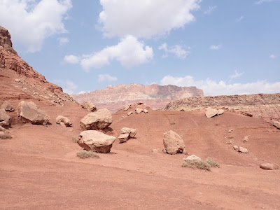
The geology in this part of the state changes from deserts ringed by hills and mountains, to giant rocks piled in odd formations.  We have no idea how they came to be here, how they were formed, anything.  Just huge giant boulders, bigger than cars, bigger than semis and trailers.  And signs all over saying don't climb on the rocks!


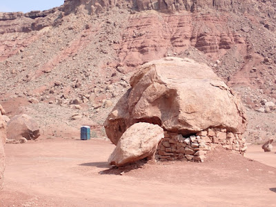
So, since there wasn't any information, we've named a few of the rock formations.


There's the Breaching Whale:


 And the Sleeping Elephant:

And of course the ever-present warning sign, in case people forget that this is the land of scorpions and venomous snakes like rattlers.


I'll close with a map showing our route around New Mexico.  I-10 goes straight from Tucson to Las Cruces, so I didn't bother to include the map of Arizona.  Our drive into NM is red, and the drive to Alamogordo and White Sands is in magenta.


Saturday, December 4, 2021

Pandemic Diaries - Year 2, Road Trip to Arizona Part V

4 December 2021


I know, we've been in two months, and I still haven't finished blogging about our drive to Arizona.  Life gets busy, things happen, and it's easy to procrastinate.  So here it is, (drum roll please), the conclusion to the Road Trip To Arizona!   Ta-dah!


We entered Arizona near the North Rim of Grand Canyon, since we've never visited this side of the canyon.  We stopped at Jacob's Lake Lodge, and tried to book a room - but they stop taking reservations for each day until 3 PM, so we decided to visit the north side of the canyon and drive back to the lodge by 3 PM or so.  (Mobile phone service is very spotty in this region, so phoning in a reservation wasn't an option.)


We picked up some items for a picnic lunch, and headed south.  The ranger at the park entrance said that the bison weren't in the large meadow, but we might see some among the trees.  Oh well, the quaking aspens were all turning golden yellow, so it was a pretty drive into the park.


The views of the canyon itself aren't as dramatic from the north as they are from the South Rim.  The vistas aren't as broad and sweeping, so we didn't see the mile drop to the floor of the canyon.  All the islands of land inside the canyon aren't visible.  Overall, it isn't as impressive.


That's not to say that the northern views aren't still pretty.  It just isn't as dramatic.  But there were side roads to viewpoints we didn't take, so we may have missed some of the panoramas.  


We stopped for lunch at a picnic area by the side of the road, and were visited by a very chatty raven.  Tall green trees where we were, the trees in the distance were green, with some little clusters of reds.  We could see canyon walls layered in reds, beige, and purples in the distance.  


And no bison hiding nearby.


We meandered and walked and stopped, and eventually drove back to the Jacob's Lake Inn.  We were able to book an adorable little cabin among the trees, and had a very restful night there.  If you're ever visiting the North Rim of Grand Canyon, this really is a great place to stay!  (Note: the elevation there is nearly 8000 feet!)


The following day, we continued on Highway 89A South, though we basically drove east to be able to drive around the canyon.  It's huge, so this is a fairly long drive.  We ended up staying in Tuba City, an interesting town on Navajo Nation land.  


For some reason, Arizona does not observe Daylight Savings Time, while the Navajo Nation does.  So Tuba City, and all the surrounding tribal land, is one hour ahead of the rest of Arizona from spring through fall.  It was very confusing to us, but oh well, humans are adaptable.  


The main reason we headed to Tuba City was that there's an ATM for our bank there, and no others along the way south until we got closer to Phoenix.  But Tuba City also has several museums, including the Navajo Cloud Talkers Museum.  The Navajo Cloud Talkers were the people during WWII who used the Navajo language to send and received coded messages.  (The Germans were never able to break the code!)  We wanted to go there, but arrived too late due to the time difference, and then we left too early in the morning.


From Tuba City, we headed to Camp Verde, but encountered several interesting sites along the way.  First, we were able to see more of the giant "steps" in the landscape, where the Colorado Plateau ends at the Vermilion Cliffs and drops down to a lower elevation plateau.


We were still on Highway 89A, heading to Highway 89 which would connect to the interstates heading south to Phoenix and then Tucson.  Highway 89A crosses the Colorado River east of the Grand Canyon, at the historic Navajo Bridge.  Just west of that bridge, we encountered one of the more puzzling sites we've ever seen.


This site was called "The Cliff Dwellers," and we expected traditional Native American dwellings carved into the stone cliffs or caves.  These weren't like that, these were individual little dwellings built around and under huge boulders that formed part of the little houses!  Really rather odd, but quite ingenious!


I wandered around, and then started to notice that some of these little buildings had some odd features that I hadn't seen in the several cliff dwellings I've visited.  First, the stone walls were formed of squared off blocks of stone, but not plastered over in adobe.  Then, the windows and doors had wood planks framing them.  And there was an actual chimney, rather than a small opening for smoke to go out of the dwelling.  Also, the buildings were square - and while I've seen some squared off dwellings built by indigenous people, with half the building a giant boulder, it would make more sense to make a rounded building around that huge rock.  The one with the chimney really looked much more like a little pioneer house in the desert!


There were several women selling jewelry and other souvenirs, so I asked if they knew anything about who used to live here, who built these homes.  No, no one had any idea.  We eventually drove on, and stopped at a shop near the bridge - I asked again, and the man at the store had no idea either.


Well, these became my burning questions - who lived here??  Who built these odd little buildings?


So of course, once we were in a place with wifi, I had to do some research.  What I found was a fascinating story of random chance, survival, and improvisation!


Back in 1927, a vaudeville dancer named Blanche Russell and her husband Bill packed up there belongings and drove to Arizona.  Bill had contracted tuberculosis, and they thought the warm dry climate of the southwest would help his medical condition.


Well, as Bill and Blanche drove through this section of Arizona, a bit west of the old Navajo Bridge, their car broke down.  There was no nearby town or service, and they were unable to repair whatever was wrong with the car.  So they decided to just camp out for the night.  


Blanche and Bill decided they liked this little spot, and they were able to build a little house up against one of the rocks.  Over the years, they continued to build and eventually established a successful trading post, complete with a restaurant and gas station!


The two stayed here for ten years or so before selling the business and moving on.  As the business expanded, it moved down the road a bit - but the original buildings remained, and these are the structures we saw on our visit.


I didn't do the original research - for more information, check out these two websites:  https://thatadventurelife.com/2021/08/18/cliff-dwellers-an-interesting-roadside-attraction-in-marble-canyon-az/  and  https://wanderwisdom.com/travelogue/Arizonas-Cliff-Dwellers-Lodge-And-Its-Unusual-Origin.


Cool story, isn't it?  Almost better than Native Americans choosing to build square buildings on lower ground rather than up in the cliffs.

Our last stop before arriving at our rental house in Tucson was Camp Verde.  There's a hotel and casino there, as well as tradition (and old!) cliff dwellings.


I wrote about the Cliff Castle, as it's called by the Yavapai-Apache Nation, who own both the hotel and casino.  The property of the actual Cliff Castle, the cliff dwelling, is now US National Park Service land, even though it's on the Yavapai-Apache Nation land.  We stayed at the hotel and I visited the actual castle in 2019 (named Montezuma's Castle by the settlers during the western expansion period).  Here's that blog:  https://rollingluggagers.blogspot.com/2019/01/


And here's the national park's website:  https://www.nps.gov/moca/index.htm


I had fun using my new camera at the Cliff Castle - the photos are much sharper, and I can zoom in and then do a super zoom for really close up photos, even when standing 1000 feet below the building.  So yes, more photos of this amazing feat of indigenous architecture!


For those who don't want to go back to my older blog, here's a summary of the info about the Cliff Castle, according to an info sign at the site:


"Between approximately 1100 and 1400, the Castle neighborhood also included a larger pueblo and numerous small alcove homes in the cliff face along Beaver Creek.


"Nestled in a limestone cliff overlooking the creek, Montezuma's Castle could have housed about 35 people.  Including families in nearby pueblos and rock shelters, perhaps 150 to 200 people made up this community.  


"In turn, these people belonged to a network of villagers united by kinship, agriculture, and cultural traditions that stretched dozens of miles along the Verde River and its tributaries, including Beaver Creek, from the Mongollon Rim to the Black Hills.  Archaeologists call this the Southern Sinagua culture area.


"These farming communities thrived until around 1350 to 1400, when people began leaving the Verde Valley, moving toward other population centers to the north and east, including those along the Little Colorado River and the Hopi Mesas."


Several Native American nations trace their ancestors to this community, so the castle is still important in these cultures.  However, the Native Americans believed that abandoned dwellings, built of natural materials, should be allowed to return to the earth through natural decomposing.  Those of us of European descent prefer to keep and maintain such dwellings as part of our combined history and heritage.  While I can see and understand both viewpoints, but I will admit that as someone who wanted to be an archaeologist when I was a child, I really do appreciate that such sites are preserved and maintained so we can still visit them.


There has been some question about what was planted by early Native American communities, and the explanation of the agricultural practices is really interesting:


"For many Native American communities, three seeds - corn, beans, and squash - represent the most important crops.  When planted together, the Three Sisters work together to help one another thrive and survive.  Utilizing the corn, beans, and squash together in your garden draws upon centuries of Native American agricultural traditions and expertise.


"The crops of corn, beans, and squash are known as the Three Sisters.  For centuries these three crops have been the center of Native American agriculture and culinary traditions.  It is for good reason as these three crops complement each other in the garden as well as nutritionally.


"Corn provides the tall stalks for the beans to climb so that they are not out-competed by sprawling squash vines.  Beans provide nitrogen to fertilize the soil while also stabilizing the tall corn during heavy winds.  Beans are nitrogen-fixers, meaning they host rhizobia on their roots that can take nitrogen, a much needed plant nutrient, from the air and convert it into forms that can be absorbed by plant roots.  The large leaves of squash plants shade the ground which helps retain soil moisture and prevent weeds."


In some of the lower portions of the castle, there were large flat stones with an indented section.  I wondered during the previous visit if these were some kind of stone used for grinding food such as corn or nuts - the base of a grinding system.  Turns out I was right - a ranger confirmed that these are grinding stones, called metate, a mealing stone.  A large round or oval stone would be used to grind the grains/nuts on the metate.


It amazes me that these items still sit there today!


Okay, more photos, the close ups and the super close ups where you can see the rocks and adobe used to build the castle.  Plus the map of our route through Arizona, with each color denoting a different day of travel.


I hope to get in another blog next week to catch everyone up on our exciting life in Arizona.  Not that it's that exciting, we are still doing a lot of isolating and trying to stay safe - but we still manage to get out and do things, as well as celebrate the holidays.  It is that time of year.