
23 October 2018

 It has been a wild and crazy week. We've travelled from just south of the US-Canadian border to a town just a bit south of the Oregon-California border. Six days, and about 625 miles. Some days we drive more, and other days we drive less and explore more.
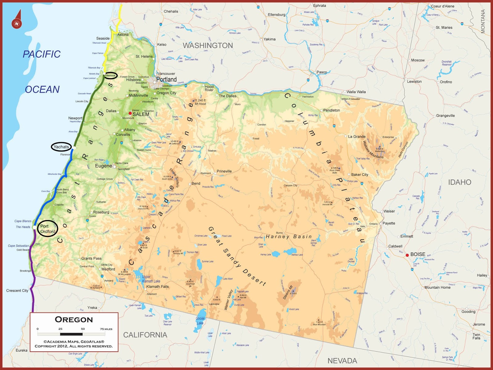
Maps are at the end, showing our route and the towns in which we've stayed. We've stopped along the way for a quick leg stretch
 at a scenic viewpoint, or a relaxing lunch. But I'm only marking the towns where we've stayed overnight.
Day 1 - We drove from Bellingham to Olympia, the
 capital of Washington state. The Lushootseed and Nisqually people were the original inhabitants of this region at the southernmost point of Puget Sound. Settlers moved in around 1853, so Olympia
  is a nice old town, not very big, with some beautiful old buildings going back 150 or so years.
 Day 2 - We awoke to a very foggy morning, and got a bit lost, but managed to get out to my alma
 mater, The Evergreen State College. Evergreen is a bit of an alternative college; instead of having general university requirements that students fulfill by attending classes in a variety of subject, Evergreen has interdisciplinary
  programs that have a focus, but incorporates a variety of subject areas that relate to that program's focus. So instead of learning something about a lot of things, students learn almost everything about several
  specific things. That's a very simplistic explanation, but it's a quick description.
Evergreen is located several
 miles outside Olympia on one of the peninsulas in the south part of the Sound, in Olympic rain forest. Much of the college's property is forest, full of
  trees, ferns, bushes, and quiet. It's a lovely setting for a college made of cement and concrete, grey buildings rising up out of all that green.
I visited the mural I helped create in my final year. A group of us studied frescoe and mosaic techniques as well as mural design under two artists, Lucienne Bloch Dimitroff and George Dimitroff, parents of an Evergreen professor. These two artists had worked with the Mexican muralist Diego Rivera, so it was an honor to study mural making under them. Each student made one or two (or three) small mosaics which were grouped together to make a wonderful collaborative mural featuring beach and sea creatures (and a single footstep on the beach). It was wonderful to see the final mural framed and mounted on the wall, to see our hard work still there, over forty years later!


The faculty and administration of Evergreen have always tried to include the culture and traditions of the indigenous people of the region, acknowledging that we who attend this school are predominantly descendants of immigrants, or former slaves or indentured servants, and thus are basically living and learning on stolen land.
There are numerous programs that include Native American cultures, one of the most obvious being the fine and performing arts.
So there is a longhouse on campus, something of a modern interpretation of a traditional Native American longhouse for meetings and special cultural events. The Evergreen longhouse has a gorgeous thunderbird carving on the front, and a series of salmon rondels and a bronze totem pole along the approach to the building. (The state mandates that a certain percentage of public buildings’ budgets be allocated for artwork, so many of the newer colleges have amazing collections of outdoor sculpture! I didn't get the name of the artist who created the thunderbird. But the metal house sculpture was made by Barbara Earl Thomas, and is titled "Story House.")
It was just wonderful to wander around the campus – so much is different, but so much is still the same. The clock tower, the college activities building, the various seminar rooms, the grassy lawn where we had commencement exercises for our very small first few graduating classes. The bookstore with tie dyed tee shirts featuring our mascot, the geoduck (a giant clam).
After about an hour of walking all around the central campus, and a slow lunch, we headed off to the coast. The morning fog finally burned off, and we had a lovely drive to Aberdeen. I remembered a quaint little fishing village, but of course Aberdeen is now bigger and bustling with activity. We found a quiet hotel and slept well.


Day 3 – More fog, insanely dense fog. We headed south along Highway 101, the coastal route.
 Driving around curves and along bluffs overlooking rivers and ocean, while in thick white fog, is a bit tense. But we’re tiki touring, travelling without a plan, so we’re
  fine with slow travel. And that’s about all you can do in thick fog, travel slowly.
The most notable feature of the day was crossing the Astoria-Megler
 Bridge. This bridge spans the Columbia River, about 14 miles inland from the actual mouth. The bridge is 4.1 miles long (6.5 km), and was completed in
  1966. At the time, this bridge was the final link in the highway system connecting Canada, the US, and Mexico.
We saw some seals playing in
 the river, and watched the river for a while. And then headed across. From the scenic viewpoint which is just about at water level, we drove
  up up up to the entrance onto the bridge, across the elevated portion and down down down to the part of the bridge that looked like it’s sitting right on the river. It probably
  is a few feet above water level, but it really feels like you’re driving on the water. Oh, and this 4 mile (6 km) long bridge? Two lanes, one in each direction. Yeah, it’s a bit of an odd bridge, but interesting. At the Oregon end, the bridge climbs back up so that the road can join the hilly town of Astoria. The elevated portions of the bridge also leave room for tall ships and boats to move underneath.
Astoria, which I remembered as a nice little beach town, actually had a cruise ship in port! So we drove south, along more winding roads with wonderful views of the ocean. My favorite town along the way was Cannon Beach, home of the famous huge conical sea stack just off the beach. The Washington, Oregon, and California coasts are littered with sea stacks, tall cylinders or cones of harder rock that remain after softer rock, soil, or clay is eroded away by the ocean. The sea stack at Cannon Beach is almost a symbol of the town, and on a beautiful sunny afternoon you can see why.
We drove through elk country, but didn’t see any. This is elk hunting season, so the elk seem to all be hiding. But I did see a bald eagle flying high above the trees as we pulled into the town of Tillamook, center of Oregon cheese production. And while Tillamook doesn’t have that sour milk scent that some cheese making towns have, the region has a definite farm-like odor permeating the area.
Yes, the little red Corolla is our new (used) car. And for people who like numbers: Washington state is 240 miles (400 km) from the border with Canada to the border with Oregon. That means we travelled 220 or so miles (375 or so km) from Bellingham to the Oregon border.


 Day 4 – Another super foggy day as we headed south once again, with more dramatic scenic viewpoints, more
  sea stacks, more views of the ocean. Plus insanely windy scenic overlooks. At least the fog was just sort of like a very fine mist, and didn’t
  include any rain with it.
We arrived in the town of Yachats, which is pronounced YAH-hots. Somehow the C is silent, no idea why it was added in there.
 Yachats is a funky little community, very Pacific Northwest. It’s the kind of town that is very green, with small locally-owned shops, cafés, and hotels, and no
  large chain stores in sight. Eateries feature locally-sourced and homemade items, everything is fresh and delicious. People are friendly, everyone looks out for each other, and it was just a wonderful little town.
Our hotel had a fabulous view of the ocean with wild and crazy waves thundering on the beach or against the rocky bluffs. I walked along the beach road, watching the flocks of sea birds struggling in the wind. There was a seal bobbing its head up periodically, but never coming in to shore. I’m not sure if it was looking for a place without people, or navigating, or just being curious. Two more bald eagles flew by overhead, soaring in the wind.
And the trees! The wind seems to be constant, causing the trees to grow in bent and twisted forms, as if they are hunched over to stay warm. While the trunks and limbs seem tortured into position, the gnarliness of the trees really makes them more interesting and beautiful than the usual upright trees.


 Day 5 – Onward and southward, with more fog, and more views. We looked at hotels in a few small towns along the way, but most had no availability. Finally, we arrived in Port Ordford, and found a motel that had just had a cancellation! This turned out to be an amazing spot – first, the manager or owner had a number of rescued feral cats living there, three of whom were quite friendly although a bit skittish. But for Phebe the Cat Whisperer, it wasn’t a problem to pet these three on their heads or under their chins, and soon they were following me around. (The other three who were newer were less ready to meet people, and were not willing to get close to me.)
Then as we were talking to the cats, a female mule deer and her fawn came walking by, nibbling on grass along the way! Mama deer wandered over to part of a small field to continue eating the grass, while I spoke gently to the fawn. He/She took several steps toward me, I took a few steps in his/her direction – but little fawn was unsure if it was okay to meet. Actually, I wasn’t sure either, so we looked at each other and seemingly decided that was close enough. Fawn joined Mama, and Richard and I went inside to unpack for the night.
And then! And then I saw huge splashes out to sea! HUGE splashes, and I have no idea how far out they were. Beyond the buoy marking the channel to the port, so a good distance out. As we watched, we could see small black oblongs (whales!) popping straight up and splashing down – spyhopping!!! Another whale leapt up and fell over sideways, breaching! They played and leapt and splashed for a while as we watched, completely entranced! SO exciting!!!
Day 6 – This morning, as I was walking around looking at the view before we left Port Ordford, I found a wonderful mosaic mural! It’s sort of a bench maybe? But it portrays the underwater reserve, all the fabulous sea creatures including our friendly whales – and ends with the fog and clouds blowing the whirling swirling wind that shapes this coast. Gorgeous!
As we drove south, we encountered rain. It turned into a super rainy day, with intermittent fog. Poor visibility, slick roads, just a yucky day. So we decided to make it an early afternoon – instead of driving our usual several hours after lunch, we found a hotel by mid-afternoon in Crescent City. Ah yes, Crescent City. Anyone who studies coastal geology, seismology, or natural disasters knows Crescent City. This town has the unfortunate distinction of having been hit by more tsunamis than anywhere else in the continental USA. Yep, thirty-one tsunamis have hit Crescent City since the early 1930s, when people began keeping records.
Our hotel is not far from the Tsunami Lanes Bowling Center. People can take a tsunami tour around the town. It’s a sad but creepily fascinating history. (And the reason for all the tsunamis is that the town sits on a crescent-shaped peninsula, so that tsunamis approaching the California coast end up reaching this town from a variety of directions, sometimes bouncing back from the mainland. It really is an interesting geological phenomenon.)
Dad's hat was absolutely thrilled to be in Crescent City (Dad having told us kids about Crescent City when he was a professor of coastal geology in Bellingham), and spent the night peering out of the car window, keeping an eye on the coastline.
We’ll continue on heading south tomorrow. I just wanted to try catching up on blogging before it became even longer!


No comments:
Post a Comment